Paul Karabinos
Charles L. MacMillan Professor of Natural Sciences
127 Bronfman Science Center
(413)
597-2079
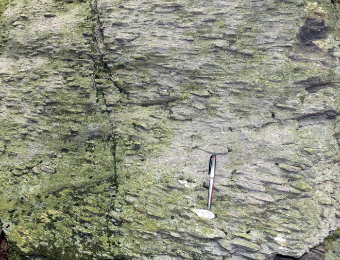
EVIDENCE FOR KILOMETER-SCALE, FLUID-CONTROLLED REDISTRIBUTION OF GRAPHITE IN PELITIC SCHIST IN THE TACONIC THRUST BELT ON MOUNT GREYLOCK, MASSACHUSETTS
Ruth Aronoff ('09), Eliza Nemser ('98), and I have been gathering evidence for kilometer-scale, fluid-controlled redistribution of graphite in pelitic schist in the Taconic thrust belt on Mount Greylock in western Massahusetts.
During the Ordovician Taconic orogeny, Neoproterozoic to Ordovician shale and siltstone from the Laurentian slope and rise were thrust over coeval shelf rocks. Flysch, eroded from the advancing thrust sheets, blanketed the shelf rocks, and was locally overridden by the thrust sheets. On Mount Greylock graphitic and non-graphitic schist are indistinguishable except for their carbon content. The graphite-rich schist was mapped by Ratcliffe and others (1993) as flysch of the Walloomsac Formation, and the contact that separates Walloomsac Formation, from graphite-poor rocks of the Greylock Schist was interpreted as a thrust. This assumed that the present distribution of graphite reflects the primary preservation of organic material in sediments. Based on our mapping, the gradational contact between Walloomsac Formation and Greylock Schist is difficult to locate and we found no strain gradients near it. In contrast, a wide zone within the Walloomsac Formation especially near the contact with the structurally lower marble is a zone of intense deformation and shares many characteristics of mélange. The distinction between graphite-rich and graphite-poor rocks is not a reliable stratigraphic tool. Typically graphite-rich (1-2 wt %) and graphite-poor (0.1-0.2 wt%) rocks are interlayered on scales ranging from 10- to 100-m. Examination of 200 thin sections reveals that 55% of Walloomsac Formation samples are graphite-rich, but 45% are graphite-poor. Although only 10% of the Greylock Schist samples are graphite-rich, 55% contain plagioclase grains with abundant graphite inclusions surrounded by a graphite-poor matrix, indicating that graphite was removed from the matrix by aqueous fluids. We suggest that graphite was widely and more evenly distributed throughout the pelitic schist, and that large-scale redistribution of graphite occurred during metamorphism and thrusting. Aqueous fluids dissolved graphite in large volumes of rock, which are now graphite-poor, but commonly contain plagioclase with abundant graphite inclusions. Faults focused fluid flow and retrograde reactions, commonly observed in fault zone rocks, consumed water and decreased graphite solubility. Graphite precipitated from these fluids to produce graphite-rich schist. Graphite weakened fault zone rocks and created a positive feedback between faulting, fluid flow, and graphite precipitation. We map the main thrust between graphite-rich schist and marble and include all of the pelites in the hanging-wall.
The kmz file below, Mount Greylock Geology, can be opened in Google Earth, and shows the distribution of schist, marble, and other rock types on Mount Greylock and in surrounding areas. Expand the Mount Greylock Geology folder to reveal individual units, which can be turned on and off by checking the boxes. A special feature of this kmz is the ability to 'switch' the Walloomsac Fromation from the hanging-wall to the footwall by toggling between "4A Ordovician_Walloomsac_Schist_Footwall.shp" and "4B ProtZ_Walloomsac_Schist_HangingWall.shp". Our interpretation is that the Walloomsac Formation belongs in the hanging-wall and is Neoproterozoic in age.
Dramatic tectonic thinning and omission of lithologic units around the Chester Dome in southeastern Vermont suggests that a ductile, normal-sense shear zone affected the region during the Devonian Acadian orogeny. Chester Dome Fieldguide (2002)
|
|
The Shelburne Falls arc in western New England formed ca.
485 to 470 Ma above an east-dipping subduction zone. Collision of the Shelburne
Falls arc with Laurentia during the Ordovician resulted in the Taconic orogeny.
After collision, a flip in subduction polarity produced a west-dipping subduction
zone near the Laurentian margin. The Bronson Hill arc formed above this new
subduction zone ca. 455 to 440 Ma. Plate convergence along this new west-dipping
subduction zone ended the Taconic orogney. Shelburne
Falls Arc Fieldguide (2003)
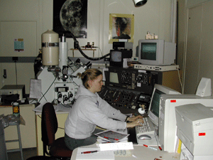
The Berkshire massif in western Massachusetts is cored by Middle Proterozoic Grenvillian crust typical of the Laurentian margin. Numerous felsic sills occur along both the eastern and western borders of the massif and in the interior, and they were interpreted as Ordovician syn-tectonic intrusives into Taconic thrust faults. In an effort to constrain the timing of Taconic deformation we used the SHRIMP to date five of the sills and discovered that there are two distinct groups of sills, neither of which are related to Taconic deformation. Sills in the interior of the massif and along its western margin crystallized at ca. 1 Ga during an intense thermal event. Granitic sills along the eastern margin of the massif formed ca. 432 Ma during the Silurian, at approximately the same time that extension began to open the Connecticut Valley trough.
Amerian Journal of Science Article (2008)
Berkshire Massif Fieldguide (2008)
Berkshire Massif Fieldguide (2003)
 |
 |
The Day Mountain thrust sheet contains a spectacular quartz-pebble conglomerate, part of the Neoproterozoic Dalton Formation, that records strain during Paleozoic deformation. A detailed strain study is underway to investigate deformation and the role of strain partitioning during thrusting.
Day Mountain Fieldguide (2008)
Visualizing Strain with an Interactive Computer Program
 |